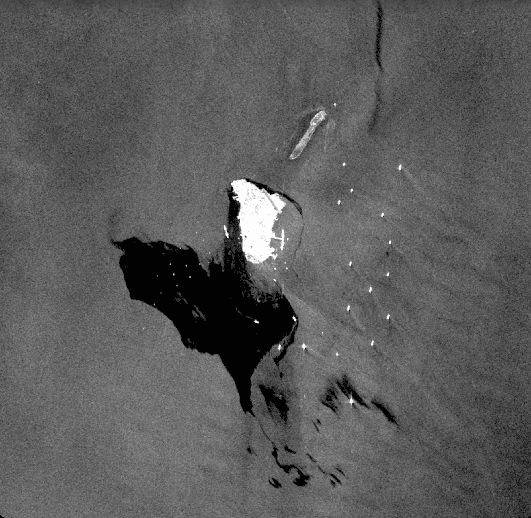
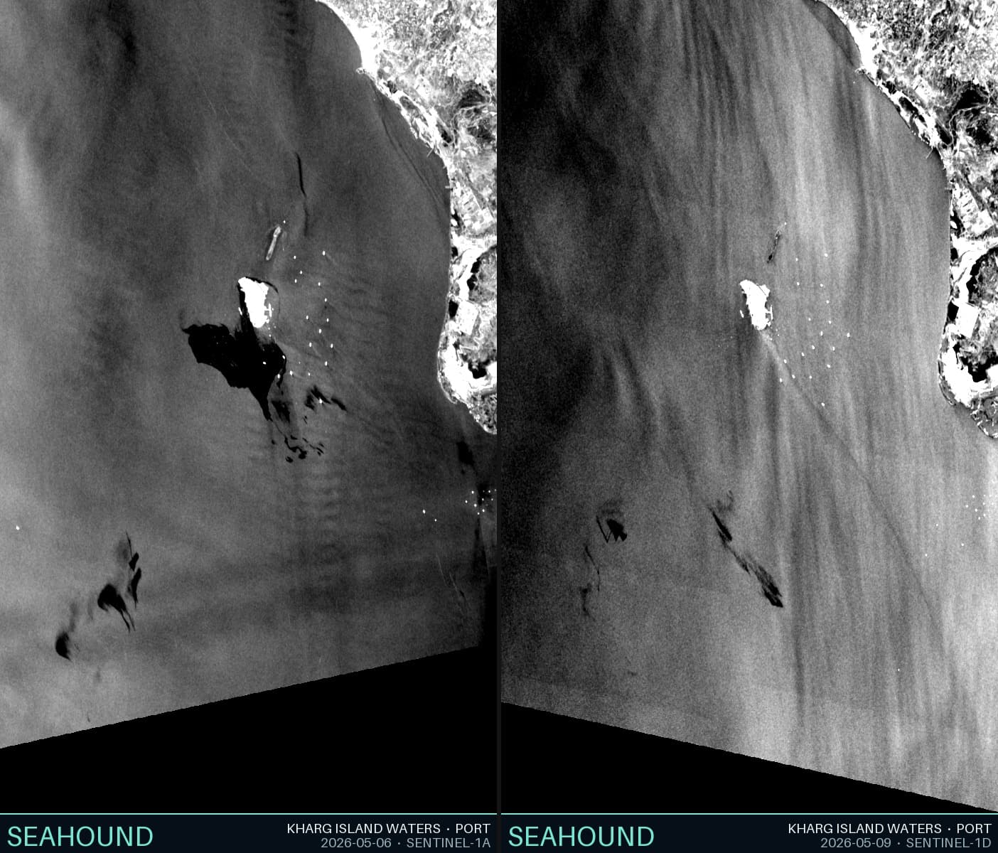
On May 6, 2026 at 14:42 UTC, a Sentinel-1 ascending pass recorded a large, continuous dark region in the northern Persian Gulf, south of Kharg Island. Three days later, on May 9 at 02:38 UTC, the same sensor geometry covered the same water. The slick was gone.
This is just an observation of what might have happened in between from physics.
Why oil appears dark in SAR
Physics
Synthetic aperture radar does not photograph light, but rather, it measures microwave backscatter. At C-band (5.4 GHz), open ocean returns strong signal because wind-driven capillary waves scatter energy back toward the sensor. Oil films, even at sub-millimetre thickness, are viscoelastic: they dampen capillary wave growth by increasing surface tension gradients. The result is anomalously low backscatter which appears as a dark patch against a textured grey ocean.
This contrast is strongest at moderate wind speeds of 3–10 m/s. Below 3 m/s the ocean is already smooth. Above 10–12 m/s, wave breaking mechanically disperses the film and the contrast collapses. This means the oil is still there, but the radar can no longer see it. A limitation for now.
What May 6 shows
The May 6 scene was acquired in afternoon local time under moderate wind conditions. The dark signature is large, spatially coherent, and elongated which is consistent with surface oil being sheared by wind and current into a thin film spread over many square kilometres. Multiple lobes visible at the southern end suggest the slick had already begun separating into streamers, a typical pattern as oil spreads and thins over time.
Three days of weathering
Oil at sea is not static. Within hours of any surface release, lighter hydrocarbon fractions begin evaporating. Within 24–48 hours, wave action emulsifies the remaining oil, mixing it with water to form a viscous “chocolate mousse” that sinks partially below the surface and becomes invisible to radar. Photochemical oxidation and microbial degradation work on slower timescales but contribute to the overall mass balance. By day three, a surface film that was optically and radar-dark may have reduced to a fraction of its original areal extent.
Why May 9 looks different
The May 9 scene was acquired at 02:38 UTC — a night pass on a different orbital track, with a different incidence angle and almost certainly different wind conditions. Our detector found 24 small candidate patches, the largest covering 0.027 km² with a contrast of 11 dB. None approaches the spatial scale of the May 6 signature.
A few mechanisms could explain this individually or together. First, the slick genuinely diminished through weathering and emulsification. Second, wind speed on May 9 exceeded the SAR detection threshold, suppressing the contrast. Third, the remaining oil drifted outside our analysis area on prevailing currents. Or, it could have been cleaned up by a response effort. We have no data to confirm or rule out any of these, but they are all plausible contributors to the observed change.
What we cannot determine from two images
Methodological boundary
Two snapshots three days apart cannot reconstruct a spill trajectory, estimate total volume, or distinguish a thinning surface film from a submerged emulsion. Since SAR is a surface sensor, anything below the top millimetres of ocean is invisible to it. A slick that disappears from radar is not necessarily gone; it may simply have changed state.
What these two images do establish is that a substantial surface anomaly existed on May 6, consistent with a hydrocarbon film, and that by May 9 it had either dissipated, submerged, removed, or dispersed beyond detection. But in some way, the ocean has to process it. Whether that processing was complete is a question the data cannot answer.
Data Appendix
Detection parameters
- Algorithm
- Seahound dark-patch CFAR (integral-image annulus)
- Guard window
- 11 px half-width
- Training window
- 30 px additional half-width
- Threshold k
- 2.0 σ below local background
- Min patch area
- 25 px (~30,000 m² at 35 m/px)
- Min confidence
- 0.5 (contrast ≥ 2.5 dB)
- Confidence
- min(mean_contrast_dB / 5.0, 1.0)
May 6, 2026 — Sentinel-1 ascending pass (14:42 UTC)
Quantitative detection not run. Visual inspection of the GCP-corrected, north-up rendered scene confirms a large, spatially continuous dark anomaly south of Kharg Island, with secondary lobes extending further south-southwest. Estimated areal extent from visual inspection: tens of km². Elongation consistent with surface drift under prevailing NW–SE current.
May 9, 2026 — Sentinel-1 descending pass (02:38 UTC) — 24 detections
- Total detections
- 24
- High confidence (≥ 0.9)
- 18
- Total detected area
- 0.162 km²
- Largest patch
- 0.027 km²
- Mean SAR contrast
- 6.85 dB
- Max SAR contrast
- 11.96 dB
- Most elongated patch
- 8.62 (major/minor axis ratio)
Full detection table — sorted by area, descending
| # | Lat | Lng | Area km² | Contrast dB | Elongation | Conf |
|---|---|---|---|---|---|---|
| 1 | 29.232 | 50.668 | 0.0271 | 10.99 | 1.50 | 1.00 |
| 2 | 28.933 | 50.065 | 0.0188 | 4.45 | 1.76 | 0.89 |
| 3 | 28.938 | 50.255 | 0.0172 | 4.79 | 6.05 | 0.96 |
| 4 | 28.843 | 50.345 | 0.0141 | 5.00 | 4.16 | 1.00 |
| 5 | 29.355 | 50.674 | 0.0140 | 8.13 | 2.63 | 1.00 |
| 6 | 29.309 | 50.671 | 0.0134 | 10.78 | 1.48 | 1.00 |
| 7 | 29.144 | 50.718 | 0.0119 | 11.71 | 1.85 | 1.00 |
| 8 | 29.467 | 50.652 | 0.0077 | 8.22 | 1.36 | 1.00 |
| 9 | 28.889 | 50.292 | 0.0072 | 2.73 | 2.29 | 0.55 |
| 10 | 28.857 | 50.345 | 0.0050 | 4.87 | 1.75 | 0.97 |
| 11 | 29.183 | 50.673 | 0.0045 | 9.61 | 1.32 | 1.00 |
| 12 | 29.293 | 50.709 | 0.0029 | 11.96 | 1.82 | 1.00 |
| 13 | 29.460 | 50.659 | 0.0028 | 7.69 | 1.83 | 1.00 |
| 14 | 29.156 | 50.644 | 0.0026 | 7.03 | 8.62 | 1.00 |
| 15 | 29.465 | 50.721 | 0.0019 | 6.36 | 3.33 | 1.00 |
| 16 | 29.463 | 50.726 | 0.0016 | 6.05 | 1.97 | 1.00 |
| 17 | 29.331 | 50.353 | 0.0016 | 2.64 | 2.38 | 0.53 |
| 18 | 29.393 | 50.666 | 0.0011 | 6.38 | 1.42 | 1.00 |
| 19 | 29.265 | 50.698 | 0.0011 | 10.48 | 1.59 | 1.00 |
| 20 | 29.320 | 50.347 | 0.0011 | 3.12 | 4.46 | 0.62 |
| 21 | 29.261 | 50.700 | 0.0011 | 10.66 | 1.53 | 1.00 |
| 22 | 29.092 | 50.730 | 0.0011 | 4.64 | 2.77 | 0.93 |
| 23 | 28.946 | 50.052 | 0.0011 | 3.43 | 3.14 | 0.69 |
| 24 | 28.882 | 50.026 | 0.0011 | 2.60 | 2.31 | 0.52 |
Detection #14 (elongation 8.62) is highly elongated — a narrow dark streak at ~29.16°N, 50.64°E — consistent with a residual oil streamer under shear rather than a speckle noise patch or low-wind cell.
Detections #3 and #4 (elongation 6.05 and 4.16, located ~28.84–28.94°N) may represent trailing fragments of the May 6 plume that drifted south on prevailing currents.
Data source: Copernicus Sentinel-1 SAR, processed via Seahound Sentinel dark-patch detection pipeline. AOI: 49.85–50.75°E, 28.30–29.65°N. Contains modified Copernicus Sentinel data processed by Seahound.